On the Sunshine Coast, the combination of steep terrain and high seasonal rainfall creates a constant challenge for hillside developments. Many times we see residential lots on the escarpments above Mooloolaba or Buderim where the topsoil is only a thin veneer over weathered metasediments. A proper landslide assessment here must start with understanding the local groundwater regime and the shear strength of these residual soils. We perform comprehensive site investigations that include test pits and boreholes, sampling undisturbed tube samples, and running direct shear tests in the lab. Before any earthworks, we recommend integrating this data with a stability analysis of slopes to model failure surfaces under both static and seismic conditions per AS 4678.
We model failure surfaces under both static and seismic conditions per AS 4678, using site-specific shear strength data from direct shear and triaxial tests.
Scope of work
A landslide assessment on the Sunshine Coast differs significantly between the coastal lowlands and the Blackall Range hinterland. In the Nambour area, we encounter deep alluvial clays with high plasticity, while around Montville the profile is shallow colluvium overlying fractured rhyolite. For each case, we tailor the investigation to the specific failure mechanism. Our methodology includes:
Detailed site reconnaissance and geological mapping of existing scarps and tension cracks
Drilling of cored boreholes for rock quality designation (RQD) and joint orientation
These results feed directly into limit equilibrium and finite element models. For sites with a history of shallow translational slides, we also conduct piezometer installation and monitoring to track pore pressure fluctuations during wet season events.
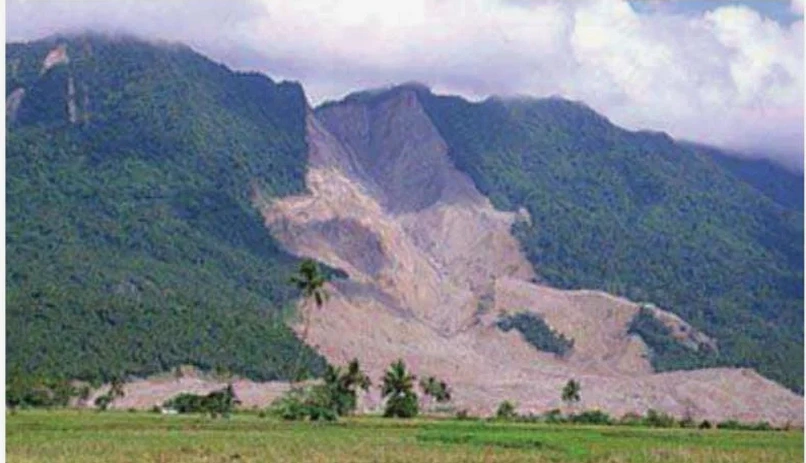
Technical reference image — Sunshine Coast
Area-specific notes
A common scenario we see on the Sunshine Coast is a three-storey house built on a cut-and-fill platform in the hills of Buderim. The fill slope, placed without proper compaction and benching, slowly creeps during wet winters. After a La Niña event with 800 mm above average rainfall, the fill failed, taking part of the backyard and the pool with it. The landslide assessment we performed later showed the fill had only 70% of the required dry density and the drainage blanket was missing. Our investigation included an infiltration test to quantify percolation rates and a back-analysis of the failure surface using residual shear strength parameters.
Direct shear (AS 1289.6.2.2) or triaxial CU (AS 1289.6.4.2)
Groundwater level monitoring
Standpipe or vibrating wire piezometers, weekly readings over 3 months
Slope geometry survey
Total station or drone photogrammetry, contour interval 1 m
Factor of safety target
1.5 static, 1.1 seismic (AS 4678-2002)
Bulk sample collection
50 kg per soil unit for compaction and permeability tests
Seismic hazard input
AS/NZS 1170.4:2007, site sub-soil class based on VS30
Linked services
01
Detailed slope stability analysis
Limit equilibrium analysis using Spencer and Morgenstern-Price methods, circular and non-circular failure surfaces, with sensitivity checks on shear strength parameters. Results include cross-sections, critical slip surfaces, and recommended mitigation measures.
02
Instrumentation and monitoring plan
Design and installation of inclinometers, standpipe piezometers, and surface survey markers. Monthly monitoring reports with trend analysis to detect early movement, allowing proactive intervention before failure occurs.
Standards used
AS 1726-2017 Geotechnical site investigations, AS 4678-2002 Earth-retaining structures (slope stability), AS/NZS 1170.4:2007 Structural design actions – Earthquake actions, FHWA-NHI-05-039 Geotechnical engineering circular no. 7 (landslide analysis)
Frequently asked questions
How much does a landslide assessment cost in Sunshine Coast?
A typical geotechnical investigation for a single residential lot ranges from AU$1,560 to AU$5,190, depending on site access, number of boreholes, and laboratory testing volume. For complex slopes requiring long-term instrumentation, the cost can go higher.
What triggers landslides in the Sunshine Coast region?
The main triggers are prolonged heavy rainfall saturating the soil profile, especially after cyclonic events, combined with steep slopes and poorly compacted fill from historical land clearing. Earthquakes are less frequent but can reactivate dormant slides.
How long does a landslide assessment take from start to finish?
A standard assessment for a single lot takes 4 to 6 weeks: 1 week for drilling and sampling, 2 weeks for laboratory testing, and 1 to 2 weeks for analysis and reporting. If instrumentation is required, monitoring extends the timeline to 3 months.