Together, we solve the challenges of tomorrow.
READ MORE →Geophysics on the Sunshine Coast encompasses a suite of non-invasive subsurface investigation techniques that measure physical properties of the ground to inform engineering, environmental and resource decisions. From the coastal plains of Maroochydore to the volcanic hinterland around Maleny, these methods reveal what lies beneath without the need for extensive excavation. The category covers seismic, electrical, electromagnetic and potential field surveys, each suited to different ground conditions and project goals. For a region experiencing rapid urban growth and facing geotechnical challenges such as reactive soils, variable rockhead and coastal erosion, applied geophysics has become an essential tool in the site assessment workflow.
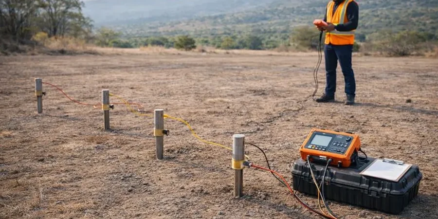
The local geology of the Sunshine Coast is dominated by the Mesozoic Nambour Basin sediments, Tertiary basalt flows of the Glass House Mountains province, and Quaternary coastal dune systems. This creates a complex subsurface mosaic where weathered basalt profiles can mask underlying rippable horizons, while saturated sands and estuarine clays along the coastal fringe present low-resistivity targets. Understanding the depth to competent rock, identifying palaeochannels and mapping the soil-bedrock interface are critical tasks made efficient through geophysical methods. For instance, MASW / VS30 (shear wave velocity) surveys are commonly deployed to classify seismic site conditions in accordance with Australian Standards, particularly where the near-surface geology transitions rapidly over short distances.
Australian regulatory frameworks directly influence the application of geophysics on the Sunshine Coast. The National Construction Code (NCC) references AS 1170.4 for earthquake actions, which requires site subsoil classification based on shear wave velocity measurements to a depth of 30 metres. AS 1726-2017 for geotechnical site investigations acknowledges geophysical techniques as valid supplementary methods for stratigraphic profiling. Additionally, Queensland’s Planning Regulation 2017 and local council development codes often mandate rigorous site assessment for subdivisions, high-rise structures, and infrastructure on land with slopes exceeding 15% or mapped as moderate to high landslide hazard. Compliance with these standards ensures that geophysical data contributes meaningfully to foundation design, retaining wall analysis and slope stability assessments.
The types of projects that routinely require geophysical investigation across the Sunshine Coast are diverse. Coastal high-rise developments in Mooloolaba and Coolum Beach need shear wave velocity profiling for seismic site classification and liquefaction assessment. Large-scale residential subdivisions in Palmview and Aura depend on electrical resistivity / VES (Vertical Electrical Sounding) to map the depth to fresh bedrock, locate groundwater tables and delineate clay-rich zones that may cause differential settlement. Infrastructure corridors, including the Bruce Highway upgrades and rail extensions, utilise continuous resistivity imaging to identify cavities, fracture zones and aggressive soil conditions. Environmental audits for former landfill sites and service station redevelopments also employ resistivity and electromagnetic methods to detect contaminant plumes and define the extent of waste deposits.
Geophysics provides continuous subsurface profiles between boreholes, reducing the risk of missing critical features like isolated boulders, palaeochannels or abrupt rockhead variations. It is non-invasive, cost-effective for covering large areas and helps optimise the number and location of boreholes, ensuring targeted drilling and more reliable ground models in the region's complex geological settings.
AS 1170.4-2007 (Structural design actions – Earthquake actions in Australia) requires site subsoil classification based on the average shear wave velocity in the upper 30 metres (VS30). This standard is referenced by the National Construction Code and is mandatory for seismic design of structures, making MASW surveys a common requirement for Sunshine Coast developments.
Yes, electrical resistivity and electromagnetic methods are particularly effective at mapping saturated zones and conductive layers associated with saline groundwater or potential acid sulfate soils. These techniques help delineate the extent of estuarine muds and marine clays common in coastal lowlands, guiding excavation management and environmental compliance requirements.
Investigation depth depends on the method and array configuration. For typical subdivisions, MASW surveys reliably achieve 30-metre penetration for VS30 classification, while electrical resistivity imaging with appropriate electrode spacing can resolve stratigraphy to depths of 20 to 40 metres, sufficient to characterise the soil-bedrock interface and inform foundation design.